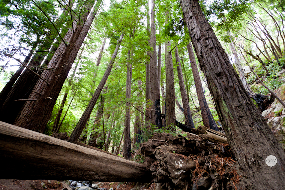
On April 21-28th I embarked on an epic adventure throughout Central & Southern California. Starting at Yosemite National Park, we worked our way down the coast to San Clemente. My brother John, his (6 month pregnant) wife Allie & my sister Rachel came along for trip. Our red-eye from ILM arrived in Los Angeles at 12:30AM Wednesday the 22nd, we picked up our Chrysler Town & Country and started the journey north to Yosemite National Park. Running on little to no sleep and a lot of caffeine, we coasted into Yosemite at around 8AM. We stopped along the way at a Walmart to get food & supplies for the next couple nights. Since it was a bit too early to check into our Yosemite accommodations at Housekeeping Camp, we decided to start exploring. Our first stop at the southernmost part of the park, was the Mariposa Grove; a stunning collection of towering Giant Seqouias.


We quickly moved on towards Glacier Point. During our planning of this trip, we noticed that the weather was supposed to be cold and rainy for the 3 days we planned to be in the park (of course it was warm and sunny before and after). It actually turned out to be a blessing in surprise, as the brief rain during the day kept some of the tourists at bay, and the cooler temps made hiking and sleeping outdoors more comfortable. In route to Glacier Point, we noticed some dark clouds moving in, so we wanted to make it there before the bottom dropped out. We were pretty fortunate that the road to Glacier Point was open this early in the season, most years it doesn’t open until early May. But since they had such low snowfall this year we lucked out. At a elevation of 7,214 ft, the point offers a superb view of Yosemite National Park’s Yosemite Valley, including Yosemite Falls, Half Dome, Vernal Fall, Nevada Fall, and Clouds Rest. It one of the most amazing places and views I have ever seen. We hung out for a while, took some photos, ate some lunch, before the weather started to deteriorate and we headed down into the valley.


We made a quick stop at the iconic Tunnel View, one of the most famous views of Yosemite Valley, which was unfortunately cased in clouds. By the time we arrived to Housekeeping Camp the rain had become pretty steady. We loaded our gear into our tent (aka 3 cinderblock walls and a canvas wall and roof, enclosing the beds). Normally we’d setup at Camp 4 with our tents, but due to the forecast of rain and Allie being 6 months pregnant, we decided this form of “Glamping” was our next best option. And it ended up being pretty swell, we got a unit right next to the Merced with views of Half Dome. Luckily we were prepared for the rain, so we suited up in our rain gear and set out to hike. We hiked across the valley to catch a view of Lower Yosemite Falls just before sunset. We managed to get a good fire going despite the earlier rain, and cooked our first meal in Yosemite over the fire. I was really looking forward to using my new intervalometer to get some good timelapses of the night sky, but the cloud cover made that a little difficult. After some much needed sleep we woke up Thursday morning to sunshine and a warm cup of coffee. We loaded up on granola bars and hit the trail towards our goal for the day, Upper Yosemite Falls. The hike up was pretty intense, but it’s hard to notice when you’re surrounded by such incredible views. This was Rachel’s first time joining us on one of our “trips” and I don’t think she knew what she was getting herself into. Me and her both were getting smoked by the pregnant girl, and Rachel wasn’t talking to us by the time we reached the top. Well, we didn’t actually make it all the way to the top, we stopped at OMG rock, which gives you a pretty awesome and up-close view of Upper Falls and an aerial view of Lower Falls. We waved at Housekeeping Camp way way way down in the valley and said, “Hey that’s where we came from!” We had our lunch at OMG rock before heading back down to the valley.


One thing I really liked about Yosemite was the bus system they have within the park. Since everything is pretty spread out in the valley, the bus system runs throughout the day, with around 25 stops at a bunch of different areas. Everything is setup in different “Villages” in the park, so it makes it really easy to explore the many options within. After our hike we decided to take the trolley back to camp. We rested a bit in camp and played a few games of horse with our kendamas. Me, John & Allie decided we were thirsty for more and decided to do some more exploring. Rachel decided to sit this next adventure out and take a nap, so we set off promising to return in an hour. 3 hours later me and John were standing on top of Vernal Falls. We always start out with small goals, then those goals expand into larger goals until we flat wear ourselves out. Our intentions were to hike to the start of the John Muir Trail, you know, just to say we hiked the John Muir Trail. But once we got there, we saw that Vernal Falls was just a “short” hike away. I’m glad we did. This was probably my favorite waterfall of the trip. Sure it’s not as tall or majestic as Upper, Lower or Bridal Veil Falls, but the amount of water flowing over the edge, and the misty wind tunnel created by its location inside a narrow valley, and the chiseled out staircase leading to the top of the falls made it pretty incredible. And I’m a sucker for waterfalls. Allie was pooped and sat out the summit push. We decided it would be a good time to head back before Rachel starts worrying.


We got back to camp, reunited with Rachel, and decided we’ve earned a meal at Yosemite Lodge for dinner. We figured for our last night in Yosemite, might as well splurge, right? I think we all got burgers and beers (except the pregnant one) and ate ourselves into a food coma. I went out again on a bridge crossing the Merced at twilight to try and capture Upper Yosemite Falls with the stars in the background. I got a bit of clouds in the shot, but it turned our fairly decent.


Our goal for the next day, and our last day in Yosemite, was to hike up to the base of El Capitan. El Cap is pretty well-known (aka famous) in the climbing world, its vertical face stretches 3000 feet from base to summit. I’m not climber, but looking up at this beast from the ground really puts in perspective how gnarly of a climb it would be and gives you a lot of respect for the guys (and girls) who conquer it. Tommy Caldwell and Kevin Jorgeson had just made a historic free-climb of El Cap’s Dawn Wall just a few months earlier. And tragically, Dean Potter and Graham Hunt died while B.A.S.E. jumping a month or so after. We decided to get our climb on and attempted to “free climb” a little ways up the the not-so-steep bottom sections. Did I mention I don’t like heights? We didn’t get very far. We hung out for a while, explored and played around the base before heading back. We made a stop at a little vista in the valley where I got some landscapes of El Capitan, then we stopped at a little picnic area, heated some coals and threw our homemade “Hobo” dinners on the coals. A must have delicacy for any camping excursion. We grubbed out and took some portraits before heading back to Housekeeping Camp to pack up our gear. Housekeeping Camp turned out to be a pretty awesome little basecamp. I mean, why would you spend loads of cash on a hotel room in the valley when you hardly spend anytime there? They have showers, bathrooms, electricity and even a camp store with anything you would need. We said our goodbyes to Yosemite and hit the road west towards Monterey and the Pacific Coast Highway.


We made it to Monterey just before sunset and took the scenic 17-mile drive through the mansions and golf courses of Pebble Beach and Pacific Grove. We stopped at the famous Lone Cypress Tree before we were incased in darkness for the back half of the drive. We cruised over to a quaint little Chili’s Restaurant for dinner and indulged ourselves in food and libations. We found a hotel for the night`in Monterey, I forget the name, it was one of those mom and pop jobbies, but nice nonetheless. We all got showers and a good night of sleep in preparation for our big drive down Highway 1 the following morning.

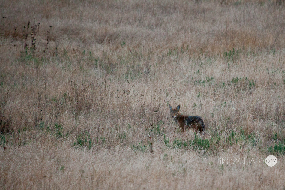
If you ever get a chance to drive down the PCH, do it! The road transverses all kinds of landscapes. From craggy cliffsides to Redwood Forests to Flat grasslands to seal filled beaches, it has it all. We made a few stops along some epic overlooks and vistas like Julia Pfeiffer State Park, McWay Falls, Bixby Bridge, San Simeon and many other unnamed spots. When we were in California a few years back we made the drive from south to north. Along that path we camped at Andrew Molera State Park. It was here where John proposed to Allie, so we knew it was a destination we had to stop for. We spent some time here, taking a brief hike to the beach to watch the surfers and take some photos on the bench set on a bluff overlooking the ocean, where John proposed. We also stopped at McWay Falls in Julia Pfeiffer Burns State Park, where a slender waterfall empties into the Pacific, conveniently located right off the highway. We try to avoid the real “touristy” stuff, but this one is worth the hassle. We continued on down the PCH to the beaches of San Simeon, where thousands of Elephant seals call their home. The stench is pretty unbearable, but it’s pretty awesome seeing these hefty beasts beached in the sand soaking in some rays, having brief spats with one another. We moved on down to Morro Bay, a quiet fishing town distinguishable by the giant rock shooting up from the shoreline, a 576 foot high volcanic plug. I walked out the beach solo to get some landscapes, where I was greeted by hundreds of pristine sand dollars, something hard to come by on the east coast. As we inched closer to Los Angeles, we realized we turned a 5 hour drive into a 8 hour drive.


In route to LA we stopped at a famous surf break called Rincon, in hopes of going for a little surf. As expected, however, it was completely flat. We took the opportunity to walk the beach and collect a fews pebbles for mementos. We arrived in LA after sunset, and just before they closed the road to Griffith Observatory. If you’re looking for a aerial view of Los Angeles, this is it. I’d recommend going at nighttime, although it seems everyone else had the same idea, as parking was absurd and we had quite a walk ahead of us to reach the top. However, the views were magnificent and most certainly worth it. We continued on towards our home for the next couple nights in Laguna Hills. Miraculously, an In and Out burger was located directly across the street from our hotel. Score! We spend the next couple days hanging out with our awesome cousins in San Clemente and surfing at Trestles in San Onofre State Beach. On our last day, we headed to LA early to walk the boardwalk in Venice Beach, check out the pier in Santa Monica and cruise the famous people stuff in Hollywood and Rodeo Drive. Another successful California trip in the books! You can view and order prints and canvases from this trip, and others, by following this link, http://prints.chriszachary.com. Help me support my travel habit by adorning your walls with some of these gems!


 We made a few stops on the way, like getting fresh orange juice from the FL welcome center (kudos to you, Flordia) and stopping through Cocoa Beach and Ron John Surf Shop (And Pizza Hut). We quickly retired to our hotel in Orlando to catch our 8 AM flight to Costa. We sucessfully made our flight without any complications (except for a few pressure dings on our surfboards, thanks JetBlue) and proceeded via shuttle to retrieve the rental car.
 They picked us a real winner of a car, a questionable, uncomforting noise was coming from under the hood as we sped off. After a quick U-Turn, and John negotiating with the fellow why we would like another car, (“Oh, it’ll be fine”, he said) his persistence paid off and we were rewarded with a sparkly white, 4×4 Daihatsu Terios.
 I’ll admit, we were a bit nervous navigating ourselves to our destination for the night, the Arenal Hostel Resort. During our first trip to Costa Rica in 2005, we unknowingly left the airport going in the complete wrong direction. Long story short, we ended up with our Terios in a ditch and were forced to drive through the night on dark, unmarked, unfamiliar dirt roads, with running out of gas a real possibility. We really didn’t want that to happen again, so we were very meticulous about our mapping. We took the longer, more scenic route, which gave us some great views of the mountainous Costa Rican countryside.
 Our first choice of hotel was the
  We got up early and got a delicious plate of comida tipica (rice, beans and in this case, eggs) from a restaurant down the street before starting our day at the Arenal Observatory. On the drive there we got some pretty incredible views of the Volcano along the tree-fence post lined dirt roads. The panoramic views from the deck at the Arenal Observatory aren’t too bad either. Then we took to the trails surrounding the volcano, where we encountered swinging bridges, wildflife and waterfalls. I went for a little swim with the GoPro at the base of the waterfall.


 Once we completed our loop, we celebrated our accomplishments with lunch and a cold Imperial at the Observatory.

 We got back to the hostel in time to pack our stuff and get back on the road to our destination for the night on the North West coast, Playa Negra.

 It was our intention (at least according to Johns itinerary) to make it there in time to get in a surf before dark. We made a bet on what time we’d get there. I guessed the latest time. I won. No surf before dark, but we did get settled into our ant infested non-airconditioned hut before nightfall at
  I slept pretty well despite the lack of air circulation, the 2 inch thick mattress and having to swat ants off me all night. John woke me up at the crack-ass-of-dawn all giddy about going surfing out front, so I rolled out of bed and complied. The waves weren’t that great but it was still fun and we had it to ourselves for the most part. We came in to wake Allie and grabbed some comida tipica and some much need cafe con leche.
  The waves pretty much went flat after breakfast so we explored the area on foot and bodysurfed in the shorebreak. Not long after we packed up the car and headed down the coast towards Nosara and our home for the next few days,


 We stayed at Harbor Reef 9 years ago during our first trip to Costa Rica and we really loved it, so we knew it was a place we wanted to stay. When we got there we were pleasantly surprised when we were upgraded to a 2 room suite complete with a kitchen! Once settled in we took a walk down the dirt paths to the beach where John caught a surf and we watched our first sunset in Nosara from Playa Guiones.

 The next few days consisted of waking up, going for a dawn patrol surf session at Guiones, grabbing our complimentary fresh fruit breakfast from Harbor Reef, exploring Nosara on foot, relaxing by the pool drinking smoothies during the hottest times of the day and going for an evening sunset surf session at Guiones. And of course we would finish the night off by the bar at Harbor Reef, playing the iconic “ring-toss” game, cooking dinner in our suite or taking a star-filled walk on the beach, before falling asleep to the sound of howler monkeys outside our suite.
 The trail to the beach.


 If I had to choose one place to stay in Costa Rica, it would be at Harbor Reef in Nosara. Get a few friends, take a bus to Nosara from San Jose, rent a couple ATV’s or dirt bikes and hang out and surf in and around Nosara. Perfection. It changed a lot since our first time going (way more gringos) but it was still super fun and relaxing. The locals had deemed Playa Guiones as Playa Goonies (probably due to all the kooky gringos). When the time came for us to check out, we looked to stay another day, but the place was booked completely and someone was scheduled to take over our suite. We knew we wanted to stay close to Nosara for another day, so we hit the interwebs to find a spot. I found
  The Lagarta Lodge is situated at the Northern-most part of Nosara, atop a cliff with Nosara on the south side and a Biological Reserve on the north. We knew the biological reserve would be our best chance at finding some monkeys.. The lodge is owned by a transplanted Swiss couple, who care less about the surf scene in Guiones and more about the conservation of Costa Rica’s wildlife and biological diversity. We drove up after our dawn patrol session on our last day at Harbor Reef to check it out and see if we could get a room. We did and we decided to take a little walk around the point. We walked along the river mouth to the beach and up on the rocks around the point before heading back to Guiones to catch an afternoon surf session.


 It gets so hot during the day in Costa, everybody retreats indoors to catch a siesta during peak hotness, so we weren’t surprised when we walked up to the beach and there only a few people in sight. (However, when we came here 9 years ago, we hardly saw anyone the whole time we were in Nosara) They have these pretty cool shelter/hut/lean-to type things on the beach at Guiones made of palm leaves and bamboo. I would guess they were made by a gringo like myself who gets sunburned just from the reflection off the sand. But I made use of them often when shooting photos from the beach. We did a little more exploring before John went back out for a sunset surf. We stayed out on the beach way past sunset and decided to splurge on our last night at Harbor Reef by eating dinner at the restaurant, having some drinks at the bar and playing a few last games of ring-toss.


 We woke up the next day, packed our belongings, went for an AM surf and headed out towards Lagarta Lodge. Once we got our stuff in our room, we started walking on a dirt road to where we thought would lead us to Playa Pelada. During our walk, we encountered what we could only describe as a Howler Monkey turf-war. We looked up and saw a group (family, pack, whatever) of about 10-15 monkeys eating leaves peacefully in the trees above us, then out of nowhere a big angry Howler came out howling (growling) ferociously at the group, essentially attempting to chase the group off of his turf. We watched in awe as these monkeys started leaping frantically, some with their babies clinging on to their backs, from tree to tree across the dirt road (watch the video at the top of the post to see, or click


 We sat there until dusk and photographed this group of monkeys. My desire to see some monkeys up close had been fulfilled! We made it back to the lodge in time to grab a couple drinks at the sunset bar to (you guessed it) watch the sunset, where we were treated to panoramic views of Playa Nosara and the Rivermouth Boca.

 Then we decided to drive down to Playa Pelada and eat at a restaurant right on the beach called


 We then parted ways with Nosara and started our drive south to our next and final stop of the trip, Playa Hermosa. Once you pass the Nicoya peninsula and get into Puntarenas, the landscape changes pretty drastically. It starts getting more mountainous, more humid (think rainforest) and a lot greener. Nosara is more desert-like I guess you could say. The roads go along some pretty precarious ridges, which make for some pretty breathtaking views. We got checked into


 We woke up early anticipating a big swell to come in overnight. It wasn’t as big as it was forecasted to be, but still some good ones coming through, I sat at the bar with my cafe con leche while John paddled out. After breakfast at the restaurant we drove in to Jaco to do a little souvenir shopping at the touristy shops there before heading back to grab smoothies, lounge by the pool with the iguanas and surf a little more. John went for another surf in the evening then we walked all the way down the beach to the point and climbed along the lava rock (fun fact: the black sand is a product of lava). We celebrated at the bar with birthday drinks and dinner, but we couldn’t party too hard because we had an early flight back to the US… Thanks for the good times Costa, till next time…